PeakFinder provides users with topographical knowledge and information about large and small mountains around the world. This is an application for people who are passionate about terrain research and mountain climbing. Until now PeakFinder has updated almost all data of mountains and mountain ranges in the world. Along with many useful information such as altitude, topography and location of these mountains, PeakFinder has become a trusted application for both amateur and professional climbers.
Introducing PeakFinder
PeakFinder is a paid application for topographic and travel research. This application was developed by Fabio Soldati and has had more than half a million downloads – not a small number for paid applications. PeakFinder Provides users with the location as well as many other information of the mountains around you. You can also use the app to search for information about mountains around the world.
Huge data
PeakFinder has succeeded in creating a large amount of data about the world’s mountains. As you may know, on our Earth there are many mountains that we probably could not climb all our lives. We often only know about mountain ranges, the largest mountains in the world, or the most extensive, but we may not know many mountains in the area where we live. Luckily PeakFinder has done this, the data they provide to users is completely accurate and comes from trustworthy sources. To do this, developer Fabio Soldati probably spent a lot of time researching and editing. This is great for such a practical application.
Some small requests
To be able to use the PeakFinder application well, your mobile device needs to meet a number of requirements such as:
- For Android operating system, minimum requirement is version 5.1 or higher, while iOS is iOS or iPadOS version 13.0 or higher.
- A minimum of 300MB of free memory is required to download and use offline maps.
- Grant location access.
- Camera access.
- Right to access data storage.
The mountains are all around you
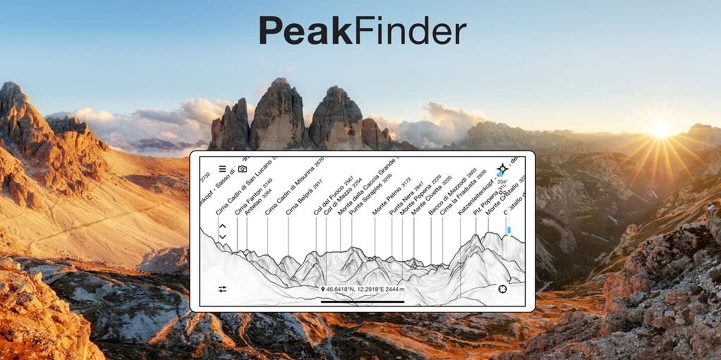
After providing the necessary permissions to PeakFinder, the application will list for you the mountains within a certain radius around you. This is shown very visually through a topographic map with names displayed in detail and the heights of the mountains. For example, Fansipan peak is displayed quite clearly with a height of 3147 meters along with information about the terrain of this place.
In addition, you can also adjust the radius to display surrounding mountains in the Visibility range section. The minimum radius is 4.9 km and the maximum is 312km. Thanks to this function you can easily detect mountains around you. Who knows, maybe there are mountains you often see but don’t know their names appearing on PeakFinder.
Viewpoint selection
PeakFinder users can not only track mountains around them but can also search for mountains in other areas. Specifically, this is the “Viewpoint selection” function of PeakFinder. You can choose from the following:
- My marks: Places you have marked in previous trips or searches. This is usually the location of the mountains, not a specific location.
- Peak directory: List of mountains in the world arranged from high to low. From here you can observe places half a world away.
- Maps (online): Use the map feature to select a specific location, then look at the mountains in that area.
- Enter coordinates: Enter coordinates including longitude and latitude to observe more specifically.
Mountain peaks in sight
Visible Peaks is a function that lists mountain ranges in your area with the radius you have selected. This function shows you the most intuitive list of mountains including name, height, current distance from you, direction and country. With this list you can also share with everyone through Kml, Gpx, Json format files. This may make more sense to many mountain and topographic researchers.
Observe with AR
The AR camera feature allows users to visually see the direction as well as compare the terrain with the actual mountains. Using the mobile device’s camera, terrains are displayed live through line drawings and mountain names are also attached. This feature is suitable for fieldworkers to easily observe the surrounding terrain, and compare and find the location of each mountain.
Download PeakFinder APK free for Android
PeakFinder is suitable for climbers and users who are planning to travel in mountainous areas. The application provides users with many interesting features and support even without an internet connection. All you need is a mobile phone that supports this application, a little skill in using the camera and reading a map. Download PeakFinder and explore this app.


Facebook comments